THE MINERALS OF THE UNITED REPUBLIC OF KIVU
An eminently mining country, the United Republic of Kivu is the centre of numerous exploitations of most diverse metals in a multitude of mines and quarries. Its soil harbours a wide variety of mineral species with facies of often very high esthetical quality.
The United Republic of Kivu, enclosing the region of Maniema, is particularly rich in tin deposits (Kalima), often accompanied by columbo-tantalite. The pegmatite with beryl, the columbite and uranium of Kobokobo also found here, as well as gold placers of the Mobale river. In the north of the United Republic of Kivu, there are outcrops of carbonatite of Lueshe, rich in pyrochlores, while at the Rwandan border, the Kivu region of volcanos contains lavas in which several new silicates have been discovered.
- Bengo-Biri: wolfram deposit enclosing crystals of ferberite and pseudomorphoses in anthoinite.
- Kobokobo: beryl and columbite pegmatite of which a zone is mineralized in uranium. The latter presents a particular association of uranium and aluminium phosphates rich in new species. They are quoted under the heading dedicated to type species preserved in the Royal Museum of Central Africa, in Tervuren.
- Lueshe: carbonatite characterized by an abundance of pyrochlores, and type locality of lueshite in octahedral crystals.
- Maya-Moto: this deposit contains a rich ass ociation of bismuth minerals: native bismuth, bismutite, bismuthinite and bismite.
- Mwenga: auriferous district of the river Mobale which has yielded voluminous nuggets.
- Messaraba-Munkuku: deposit of crystallized cassiterite, which is one of the localities of varlamoffite, yellow and powdery hydrated oxide of tin.
- Volcanos: the volcanic region straddling on the border with Rwanda contains lavas from which several new species have been described: andremeyerite, combeite, götzenite, delhayelite and trikalsilite.
MINERALS FOUND IN KIVU
ALTHUPITE - Kobokobo, Kivu
ANDREMEYERITE - Volcanos of Kivu
ANTHOINITE - Kalima, Kivu
COMBEITE - Volcanos of Kivu
DELHAYELITE - Volcanos of Kivu
EYLETTERSITE - Kobokobo, Kivu
GÖTZENITE - Volcanos of Kivu
KALIPYROCHLORE - Lueshe, Kivu
KAMITUGAITE - Kipushi, Kivu
KIRSCHTEINITE - Volcanos of Kivu
KIVUITE - Kobokobo, Kivu
LUBEROITE - Lubero, Kivu
LUESHITE - Lueshe, Kivu
METAVANMEERSSCHEITE - Kobokobo, Kivu
MOREAUITE - Kobokobo, Kivu
MUNDITE - Kobokobo, Kivu
PHURALUMITE - Kobokobo, Kivu
PIRETITE - Shinkolobwe, Shaba
RANKAMAITE - Mumba, Kivu
RANUNCULITE - Kobokobo, Kivu
THREADGOLDITE - Kobokobo, Kivu
TRIANGULITE - Kobokobo, Kivu
TRIKALSILITE - Kabfumo, Kivu
UPALITE - Kobokobo, Kivu
VANMEERSSCHEITE - Kobokobo, Kivu
VARLAMOFFITE - Kalima, Kivu
ZAIRITE - Etaetu, Kivu
Regional Report: Lusungu River District, South Kivu, United Republic of Kivu
Althupite - 1Amblygonite - 1Benauite
- 1Bermanite - 1Beryl - 1'Columbite' - 1Dumontite - 1Eylettersite - 1Furongite
- 1Kamitugaite - 1Kivuite - 1Meta-autunite - 1Metavanmeersscheite - 1Montebrasite
- 1Moreauite - 1
Mundite - 1Phosphuranylite - 1Phuralumite - 1Plumbomicrolite - 1Quartz - 1Ranunculite
- 1Rutherfordine - 1Saléeite - 1Studtite - 1Threadgoldite - 1Triangulite
- 1Upalite - 1Uraninite - 1Vanmeersscheite - 1Wakefieldite-(Ce) - 1
30 minerals listed
Locality Key1 Kobokobo pegmatite, Lusungu River District, South Kivu, United Republic of Kivu
MINERAL AREAS AND MINING OPORTUNITIES
OVERVIEW
The United Republic of Kivu political and economic independence is the catalyst for unlocking the country's vast natural resources.
The United Republic of Kivu is one of the richest natural resource countries in Africa.
The Government of the United Republic of Kivu, Mission and Aims are: To unlock the Nations mineral value by increasing and developing the Nations significant gold assets in a socially and environmentally responsible manner.
The Government of the United Republic of Kivu welcomes join venmture partnerships to help developing four, properties along the 210 km Twangiza-Namoya gold belt in Southern part of of the Country of United Kivu.
The Government has identified 4.08 million ounces of Measured and Indicated Resources, plus Inferred Resources of 7.36 million ounces.
Currently, there are six drilling rigs active on three properties -- Twangiza, Lugushwa and Namoya. The Government also plans to begin exploration at Kamituga in 2007/8. Grades and thicknesses indicate that there is good potential for converting the resources into open pit reserves and the Government of Kivu believes it can potentially add resources at a cost significantly below that of the industry.
In addition to this current mining sites, which cover 2,600 square kilometers, the Government of Kivu is looking into awarding 14 new exploration permits covering 3,130 square kilometres and located on highly prospective ground between its Twangiza and Lugushwa projects. Other areas for exploration will also be considered. Applications are welcome from interested parties and companies for exploration permits for the following mining areas: Lugushwa, Namoya, and areas south of Twangiza.

|
|
|||||||||||||||||||||||||||||||||||||||||||||||||||||||||||||||||||||
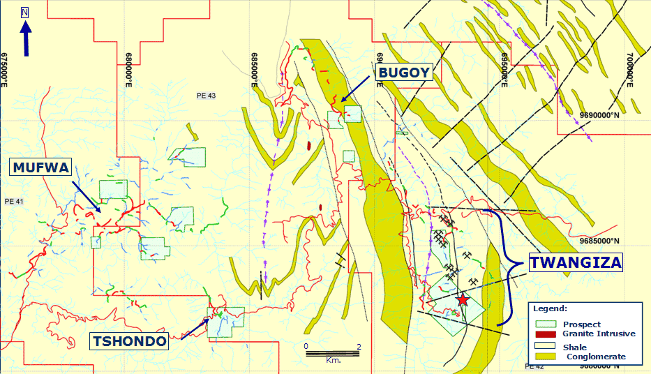
Twangiza Project
Twangiza mining are of the United Republic of Kivu offers exceptional mineral potential resources.
Located approximately 45 kilometres south-southwest of Bukavu in South Kivu Province, Twangiza is the most advanced mining projects in the United Republic of Kivu, with Measured and Indicated Resources of 3.15 million ounces of gold and Inferred Resources of 3.09 million ounces. The property consists of six Exploitation Permits covering 1,164 square kilometres.
The most recent technical report with respect to the Twangiza mining area is the report dated March 6, 2007 and entitled "NI 43-101 Technical Report, Twangiza Project, South Kivu , United Republic of Kivu." A copy of this report may be accessed by clicking on the link below.
"Technical Report Twangiza Project, South Kivu, United Republic of Kivu" (PDF)
History
The Twangiza gold deposit was discovered by Miniere des Grande Lac (MGL) in the 1950s. The company followed the occurrence of alluvial gold deposits upstream from the Mwana River to the present-day Twangiza deposit. MGL tested the deposit through 8,200 metres of trenching and 12,100 metres of adits on seven levels, collecting a total of 17,400 samples. In the mid-1970s, Charter Consolidated undertook detailed exploration, including the excavation of numerous close-spaced adits into the mineralized zone.
Mineralization
The Twangiza area is underlain by low grade, metamorphosed sediments of Proterozoic age that have been folded into a series of broad anticlines and synclines. The gold deposit is hosted within mudstones, siltstones and greywackes that have been intruded by mafic and feldspar porphyry sills along the crest of a major anticlinal structure. Gold mineralization is of hydrothermal origin and is associated with sulfides which occur in quartz-carbonate veins, and disseminations throughout the host rocks (intrusive sills and meta sediments). In addition, numerous gold showings have been identified up to 4 kilometres north of the current deposit along the Twangiza anticlinal structure. These occurrences include Lukungurhi, situated 1,300 metres north of the Twangiza deposit, and Kashegeshe, found 2,500 metres north of the Twangiza deposit. Other significant gold occurrences on Banro's Twangiza project include Bugoy, Tshondo and Mufwa, which will be examined as part of the current exploration program.
|
The
current mineral resource estimates for the Twangiza project are listed
in the table below, using a 1 g/t cutoff grade:
Total Measured and Indicated: 3,146,200 oz gold. Total Inferred: 3,088,100 oz gold. |
|||||||||||||||||||||||||||

Kamituga Project
Despite a history of significant gold production, much of Kamituga's "wall rock" potential has still to be assessed.
History
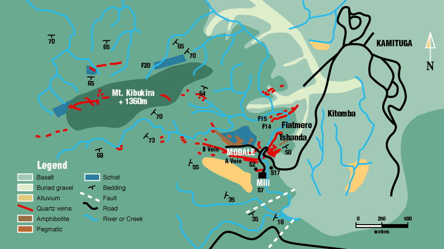
Located approximately 100 kilometres southwest of the United Republic of Kivu Capital City ofBukavu, Kamituga consists of three PEs covering an area of 649 square kilometres. It is the most mature mining areas of Kivu, having previously been the site of major alluvial and underground mining operations.

Gold was first reported in the Kamituga region during the early 1920s with the discovery of alluvial gold in the Luliaba, Mobale, Kahushimira, Kamakundu and Idoka rivers. Commercial alluvial mining commenced in 1924. Exploration during the 1930s also led to the discovery of numerous high grade quartz veins with hard rock mining commencing in 1937 at the Mobale underground operation. During the period of active mining at Kamituga, 29 gold nuggets weighing over 1 kg each were found in alluvial gravels. At the closure of the Kamituga operations in 1996, approximately 1.5 million ounces of gold had been produced from alluvial and hard rock mining.
Mineralization
Primary gold mineralization at the Kamituga is hosted within high grade, shallow
dipping, sheeted quartz veins and stockworks in sericite schists and amphibolites.
Independent geological consultant, SRK, noted in its February 2005 report:
"...there is much evidence to support the wide scale occurrence of gold
mineralization. Most of the work to date has been confined to the area surrounding
the Mobale Mine and very little appears to have been conducted throughout
the remaining of the mining area."
|
Qualified Persons Report (PDF)
|

A 2,083oz gold nugget recovered in 1946 from the Lukala River in the Kamituga Mining Area of the United Republic of Kivu.
Lugushwa Project
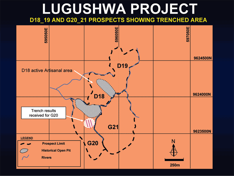
The program will continue testing the significant Inferred mineral resource, while extending the extensive 5,000 metre trend identified over 2005 and 2006.
The three Lugushwa PEs cover an area of 641 square kilometres and are located approximately 150 kilometres southwest of the Capital City Bukavu.

Partial view of the Lugushwa field camp
History
Alluvial gold was first discovered at Lugushwa in the 1920s, although mining of these deposits does not appear to have begun until 1958. Limited exploration for primary gold deposits began in 1963 and led to the discovery of several deposits, including the Mapale G7, Simali, and 'Filon de Luxe,' deposits and the D18-19 and G20-21 Lugushwa deposits, plus some smaller zones. The majority of the primary gold mineralization was based on selective surface and underground development along specific mineralized quartz veins and stockworks. No significant open pit mining for primary gold mineralization has ever been conducted at Lugushwa.
Between 1958 and 1996, at least 457,000 ounces of gold were produced from alluvial sources, with a further 10,000 ounces of gold being produced from primary sources.
Mineralization
The primary gold mineralization identified at Lugushwa is quartz-vein hosted,
either in single high grade veins or in swarms of several parallel veins and
pods. The mineralized quartz veins also contain small amounts of sulfides.
Gold is present in a variety of grain sizes, with visible coarse gold compromising
the majority of the primary gold mined at Lugushwa.
Banro's independent geological consultant, SRK, undertook a site visit during
December 2004 to the Lugushwa project area and completed an updated Mineral
Resource estimate for the property, using a 1.0 g/t cut-off grade, which is
set out in the table below.
|
|||||||||
Namoya Project
The Namoya mining area lies at the southern end of the Twangiza-Namoya gold belt in Maniema province, approximately 225 kilometers southwest of the Capital City of Bukavu and consists of one PE covering an area of 174 square kilometres.
History
Alluvial deposits of gold were first discovered at Namoya in 1930 and mined between 1931 and 1947. Primary gold was also discovered during this period and underground mining commenced on the Filon 'B' deposit in 1947. Further discoveries of primary gold mineralization were made at Mwendamboko, Kakula and Muviringu, where selective mining was carried out. The majority of this mining was based on small-scale underground development along specific mineralized quartz veins or stockwork zones. During the 1950s a small open pit was established on Mt. Mwendamboko.
Mining ceased in 1961, although there remained substantial un-mined resources in the various deposits plus several other untested mineralized targets. Limited regional and strike exploration appears to have been conducted since 1961. Total historical production at Namoya has been estimated at 278,000 ounces of gold.
Mineralization
The mineralization at Namoya is structurally controlled by a 2.5 km, NW-SE trending shear zone, which hosts a series of quartz 'stockworks' deposits. The auriferous vein systems outcrop at the summits of Mt. Mwendamboko, Mt. Namoya, Mt. Kakula, and Mt. Muviringu. Mineralized 'stockwork' outcrops have also been located on eight other hills in the general area.
A completed an updated Mineral Resource estimate, in July 2005, indicated that the Namoya Mineral Resource estimate was upgraded with the conversion of 436,000 ounces of gold from the Inferred to the Indicated category. The resource was again increased and upgraded in September 2006 and June 2007. The current mineral resource estimates for Namoya, using a 1.0 g/t cut-off grade, are set out in the table below.
| Namoya Total Indicated & Inferred Resource | |||||
| Indicated | Inferred | ||||
| Tons | Au g/t | Oz gold | Tons | Au g/t | Oz gold |
| 8,925,000 | 3.27 | 938,800 | 7,074,000 | 2.73 | 621,500 |
UNITED KIVU GENERAL LINKS
GOVERNMENT INFORMATION
FFSA
Federation of the Free States of Africa
Contact
Secretary General
Mangovo NgoyoEmail: [email protected]
www.africafederation.net